Vile Vortices
Explaining the Vile Vortices
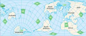
By definition, the Vile Vortices would be miserable whirlers but actually they are twelve vertex points of a planetary grid (see Figure 1) originally plotted by Ivan T. Sanderson, a naturalist and paranormal investigator. Sanderson first coined the term, “Vile Vortices”1 in his article “The Twelve Devil’s Graveyards Around the World” (Saga magazine, 1972).
The best-known Vile Vortices are the Bermuda Triangle, the Dragon’s Triangle (Devil's Sea), and the South Atlantic Anomaly. However, each of these twelve geographic areas is credited with instances of magnetic anomalies and other unexplained phenomena.
Plotting the Vile Vortices
Ivan T. Sanderson, the founder of the Society for the Investigation of the Unexplained, was avidly interested in investigating ship and plane disappearances linked to the paranormal. In the late 60’s he focused his attention on ten areas that were approximately equidistant and were the subjects of reported unexplained incidents and/or electro-magnetic distortions2.
Ten of Sanderson’s Vile Vortices are located in the earth’s tropical climates; five of them fall within the Tropic of Cancer and the other five within the Tropic of Capricorn. The remaining two Vile Vortices are located at the North and South Poles. Together the Vile Vortices form the vertices of an icosahedron (a 20-faced polyhedron) 3.
Sanderson theorized that hot and cold air and sea currents crossing these lozenge-shaped areas might create the electromagnetic anomalies responsible for the disappearances of planes and sea-going vessels and the reported mechanical and instrument malfunctions in these areas.1
Merging the Vile Vortices into the Planetary Grid
In 1973, three Soviet scientists (Nikolai Goncharov, Vyacheslav Morochov, and Valery Makarov) extended Sanderson’s theory in their article, “Is the Earth a Large Crystal?” published in a Soviet science magazine.3 They postulated that "a matrix of cosmic energy" made up of twelve pentagonal plates covers the earth. The article claimed that the junctions of any three of these plates (62 junctions in all) possessed unusual properties such as advanced prehistoric cultures, unique wildlife, or other mysterious phenomena.
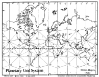
The work of the Russian scientists outlined a planetary grid that built on Sanderson's original twelve Vile Vortices (see figure 2), overlapping Sanderson's icosahedron with a combination of icosahedrons and dodecahedrons in parallel with many of the earth's seismic fracture zones, ocean ridges and additionally portrayed the earth’s atmospheric highs and lows, routes used by migratory animals, and gravitational anomalies as well as the locations of ancient civilizations."2
However, planetary grid systems date back to the time of Plato (approx. 427-347 BCE). Plato theorized that the earth’s basic structure evolved from simple to complex geometric shapes; the cube, tetrahedron (3 sides), the octahedron (8), the icosahedron (20), and dodecahedron (12), known today as the platonic solids. He associated four of the five shapes with, respectively, the elements of earth, fire, air, and water and the dodecahedron with the earth’s prana/aether (life sustaining force).2,4
David Hatcher Childress, author of Mapping the World Grid observes “...we are speaking about an intelligent geometric pattern into which, theoretically, the Earth and its energies are organized—and possibly in which the ubiquitous megalithic sites are also positioned.”5
The Vile Vortices on the Planetary Grid
| Vortices in the Tropic of Cancer | Vortices in the Tropic of Capricorn |
| 12. Mohenjo Daro, site of the Rama Empire 14. The Devil’s Sea (Dragon’s Triangle) 16. Hamakulia, near Hawaii, the scene of high volcanic activity 18. The Bermuda Triangle 20. The Algerian megalithic ruins 61. The North Pole |
41. The Zimbabwe Megaliths 43. Wharton Basin, the site of the Wallaby Fracture Zone, 45. The edge of the Hebrides Trench near the Fiji Islands 47. Easter Island Colossi 49. The South Atlantic Anomaly 62. The South Pole |
Figure 2: The Planetary Grid System shown in figure 2 was inspired by an original article by Christopher Bird, "Planetary Grid," (New Age Journal #5, May 1975, pp. 36-41). The hexakis icosahedron grid, coordinate calculations, and point classification system are the original research of Bethe Hagens and William S. Becker. This map is displayed with permission of the authors in cooperation with Governors State University,University Park, Illinois.
1.Dan Shaw. “12 Devil's Triangles-10 Vile Vortices Around the World.” Vortex Maps 2007. 27 Apr 2008 <http://www.vortexmaps.com/devils-triangle.php>.
2.William Becker, Beth Hagens. “The Planetary Grid–A New Synthesis.” Bibliotecapleyades Unknown. 28 Apr 2008 <http://www.bibliotecapleyades.net/ciencia/antigravityworldgrid/ciencia_antigravityworldgrid02.htm>.
3.“Vile Vortices.” Wikipedia 21 Feb 2008. 18 Apr 2008 <http://en.wikipedia.org/wiki/Vile_Vortices>.
4.“Earth's Grids .” Crystalinks unknown . 28 Apr 2008 <http://www.crystalinks.com/grids.html>.
5.David Hatcher Childress. “Mapping The World Grid.” Bibliotecapleyades unknown . 28 Apr 2008 <http://www.bibliotecapleyades.net/ciencia/antigravityworldgrid/ciencia_antigravityworldgrid01.htm>


